

Dholera Smart City

Dholera Smart City
Dholera Smart City is India’s first and largest planned greenfield industrial smart city, located in the Dholera district of Gujarat.
Backed by the Delhi-Mumbai Industrial Corridor (DMIC) and developed under the Gujarat Government’s Smart City initiative, Dholera is rapidly emerging as one of India’s most promising investment destinations.
Why Invest in Dholera
World class infrastructure and connectivity (Expressway, Metro, Airport).

Huge industrial potential (Special Investment Regions).

Sustainable design and green development principles.

Fast rising property value and government-backed security.
Invested in Dholera
Tokyo Electron (TEL)
Semiconductor Equipment Support & Office Presence
Local office & Support Centre
READ MORETypes of Dholera Maps Available
As of March 2025, Dholera Special Investment Region (SIR) is gaining momentum with major developments like Tata’s semiconductor plant, Renew Power’s solar manufacturing facility, and the near-complete Ahmedabad Dholera Expressway. in this article we talk about Dholera city map and These projects position Dholera as a hotspot for real estate investment, industrial growth, and job creation, making it a trending topic for investors worldwide.
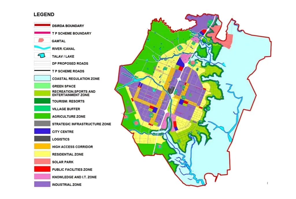
1.Dholera City Map – A Blueprint for Smart Living
The Dholera City Map offers a detailed overview of the entire smart city, highlighting key zones and development areas. Perfect for investors and planners, this dholera town planning map showcases:
- Residential and Commercial Zones : Affordable housing, luxury townships, and commercial hubs poised for high ROI.
- Industrial Hubs : Locations for manufacturing, IT, and logistics, including Tata’s upcoming semiconductor facility.
- Green and Recreational Spaces : Sustainable parks and leisure areas promoting eco-friendly living.
- Key Amenities Planned schools, hospitals, shopping centers, and entertainment zones for a high-quality lifestyle.
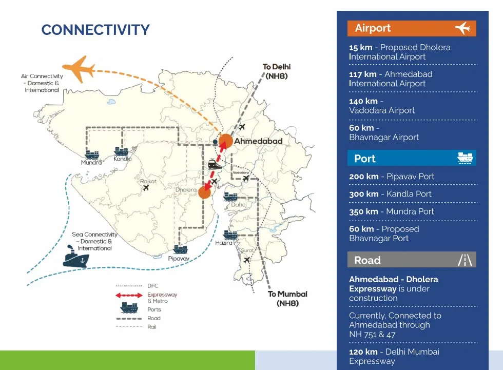
2. Dholera Gujarat Map - Connectivity at Its Core
The Dholera Gujarat Map positions Dholera within Gujarat, emphasizing its strategic location and connectivity to major cities like Ahmedabad (100 km away), Gandhinagar, and Bhavnagar. This map is essential for:
- Regional Context : Understanding Dholera's proximity to Gujarat's economic powerhouses.
- Transportation Hubs : Proximity to Dholera International Airport (under construction) and seaports for global trade.
- Travel Planning : Easy access via the Ahmedabad-Dholera Expressway and proposed metro connectivity.
Investor Insight: With Gujarat attracting 72,000-3,000 crore annually in Dholera land investments (as of late 2024), this dholera sir map with planning highlights why Dholera is a top choice for long-term growth.
A downloadable Dholera map PDF offers high-resolution details of the city's layout. This is ideal for those looking for offline access to the city plans. You can:
- Zoom into specific regions.
- Print the map for reference during visits.
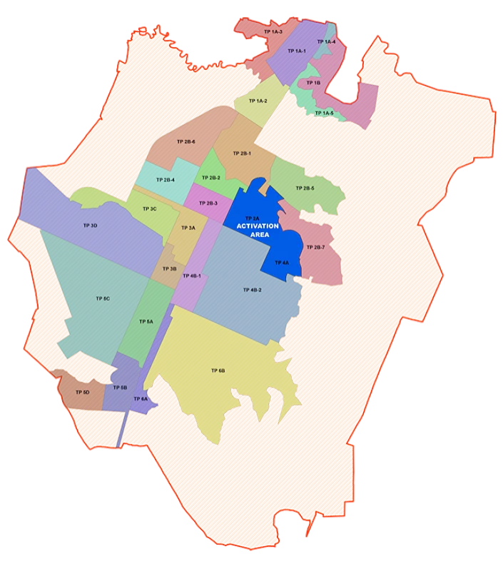
Dholera SIR Map
The Dholera SIR map focuses on the Special Investment Region. It highlights:
- Industrial Corridors : Zones for semiconductors, renewable energy (e.g., Renew Power's 2 GW solar plant), and logistics.
- Logistic Parks : Multi-modal hubs enhancing trade along the Delhi-Mumbai Industrial Corridor (DMIC).
- Utility Infrastructure: Solar-powered grids, water treatment plants, and zero-waste systems for sustainability.
2025 Update: Recent drone surveys by Drone Acharya (March 2025) provide updated SIR layouts, ensuring precision for investors eyeing industrial plots.
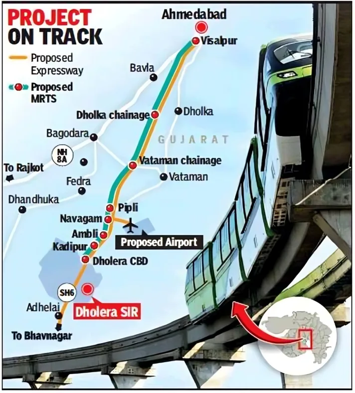
Ahmedabad-Dholera Expressway Route Map - Speeding Up Growth
The Ahmedabad-Dholera Expressway, nearing completion in 2025, slashes travel time between Ahmedabad and Dholera to under an hour. This route map details:
- Alignment : A 6-lane expressway connecting key industrial and residential zones.
- Interchanges : Strategic entry/exit points for seamless access.
- Connectivity : Links to the DMIC and Dholera International Airport for global reach.
Investor Investor Benefit: Faster connectivity boosts property values and accessibility, making Dholera plots a trending investment choice in 2025.
Dholera Guide instead of Dholera
Instead of types of Dholera Maps available, we want to mention Dholera City Map: A Strategic Guide to India’s Emerging Investment Hub
As of December 2025, the Dholera Special Investment Region (SIR) is witnessing rapid momentum driven by landmark developments such as Tata Group’s semiconductor manufacturing plant, ReNew Power’s solar manufacturing facility, the Ahmedabad–Dholera Expressway, the upcoming Dholera International Airport, and Lothal, where the world’s largest National Maritime Heritage Complex is under development—set to become the next major tourist hotspot.
This section explains the Dholera City Map, helping investors understand why Dholera is becoming a global hub for real estate, industry, and employment.
Instead of Dholera sir Map – Dholera SIR (SIR in CAP) In Dholera Gujarat MAP, Ride Side Corner Image, it is mentioned that Ahmedabad - Dholera Expressway is under construction, Want to remove only Is under Construction.
At Prominent Developers Infra LLP, we help you identify the right plots and investment opportunities in Dholera to secure your future in this landmark development.